NewNOTIFICATION FOR THE REMOTELY PILOTED AIRCRAFT SYSTEM (RPAS)/ DRONE CERTIFICATE PROGRAMME- JANUARY 2024
Dr. R. Satheesh Centre for Remote Sensing and GIS (formerly known as the Centralized Remote Sensing and GIS Facility, renamed after the first Co-ordinator of the Facility and Reader of the School, late Dr. R. Satheesh), the first of its kind in a university in Kerala is established by the University as a ‘Centre of Excellence’ in the field of Remote Sensing and GIS applications with technical and financial support from the Indian Space Research Organization (ISRO), Dept.of Space, Govt. of India under the National Natural Resources Management System, Sub Committee on Technology and Training (NNRMS-SC-T) Programme as a joint venture of the University and ISRO. The facility was inaugurated by Dr. G. Madhavan Nair, former Chairman, ISRO on March 15, 2003.
OUR LOCATION
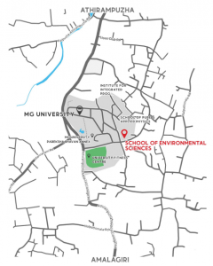
| Dr. R. Satheesh Centre for Remote Sensing and GIS is located in the Mahatma Gandhi university campus, Priyadarsini Hills, Athirampuzha 13 kilometers from Kottayam Railway Station and 4 kilometers from Ettumanoor. To reach the campus take the deviation from M.C. Road at Ettumanoor or Gandhi Nagar. The nearest airport is Cochin International Airport situated at Nedumbassery, Cochin which is about 80 km away. Private buses to Ernakulam starting from the Nagampadom bus stand at the northern end of the railway platform at Kottayam stop at the university. It is located 13 km away from the city of Kottayam. |  |
SPECIAL FEATURES
STATE OF THE ART FACILITIES
Labs
GIS and Remote Sensing lab
AutoCAD lab
Survey and Drafting lab
Photogrammetry and Visual lab
Softwares Available
ArcGIS 10.5.1
Surfer V23
Erdas Imagine 2015
AutoCAD 2D
Equipment’s
Total Station Equipment
DGPS
Spectroradiometer (Visible- IR range)
GPS- Garmin
Distometre
Planimetre
TruArc™ 15 Compass
Brunton- Omni Sight Sighting Compass
Brunton- Omni Slope Sighting Inclinometer
Brunton- Standard Transit

SHORT TERM COURSE IN GEOINFORMATION SCIENCE AND TECHNOLOGY
Geomatics is a comprehensive term applied to the Geoinformation Science and Technology – the powerful combination of various spatial and data processing technologies namely: Remote Sensing, Photogrammetry, Mapping and Surveying, GPS, Information and Communication Technology (ICT) and GIS.
The Structure and Content
The course is designed by experts to provide sufficient knowledge and advanced training in the field of RS, GIS and GPS. The theoretical and practical modules consist of fundamental concepts of Remote Sensing, Digital Image Processing, GIS, GPS, Database Design, Computer and ICT, Information Analysis and modelling.
The courses highlights on various application fields like, Natural Resource Management , Utilities Management, Urban and Regional Planning, Land or Urban Information Systems and Municipal GIS, Customisation and Application Software Development.
The Course Module
Target Group and Eligibility
Graduates / Post Graduates and researchers/scholars in Biology, Physics, Chemistry, Geology, Geography, Ecology, Environmental Science and Management, Agriculture, Forestry, Architecture, Town and Country planning, Civil engineering, Electronics, Computer Science, Mathematics, Community Medicine, Commerce and Management can apply. Working professionals and senior and middle level officials from corporate bodies, government departments, agencies, NGOs, local self-governments and researchers and academicians from universities, colleges and institutions can participate the training as sponsored candidates.
Duration and Periodicity
The duration of the course is 6 months (24 weeks) comprising of theory, practical and project work. There will be two batches in a year commencing in March and September every year.
Fee Structure
Prior Registration: Rs.1, 000/-
Course Fee : Rs. 32,000/- (Include prior registration fee and can fee and can remit in 2 installments.)
Caution Deposit : Rs. 1,500/- (Refundable)
Evaluation and Certification
The participants will be evaluated through internal assessment, final examination for theory and viva- voce for the project work. Participants will be graded based on the marks gained and the successful candidates will be issued proficiency certificates.be issued proficiency certificates.
Placements
Placement support will be given to all the students as per the demand of various research institutions, government organization and companies. Alumnus of the course are working under various government organisations, NGOs and companies like WIPRO, Infosys, Trimble, Garmin, Genesys, Map My India, PAN Environ India, ULCCS etc.
How to Apply
The application form downloaded from the website https://ses.mgu.ac.in/ . The completely filled application form along with the Application+ Registration fee of Rs 250/- as DD drawn in favour of Director, School of Environmental Sciences, Mahatma Gandhi University should be mailed (registered/ speed post only) to the The Co-ordinator, Dr. R. Satheesh Centre for Remote Sensing and GIS, School of Environmental Sciences, Mahatma Gandhi University, Priya Darshini Hills P. O., Kottayam – 686 560. Kerala, India. Mob: 9446767451.
Those who want to reserve their seats while applying itself should send a single DD of Rs.1,250/- (Rs. 1,000/- is the amount that is paid from the course fee in advance to book the seat), provided the qualifications are matching with the requirement. This arrangement is due to the admission policy of ‘First-Come First Serve‘
Brochure of the short term program
How to apply for Short term course in Geoinformation Science and Technology
Application form for Short term course in Geoinformation Science and Technology
Syllabus of SHORT-TERM COURSE IN GEOINFORMATION SCIENCE AND TECHNOLOGYGISTC
OTHER PROGRAMMES
Every year during the month of August we are offering an online internships programme for the Academicians, Professionals, Scholars and Students. The duration of the programme will be 30 days and Internship certificate also will be provided at the end of the course based on the attendance in the online sessions.
Interested persons can do offline internship for any duration during any months at the centre also (Fee:- Rs. 5000/month).
Guidance and supports are given for students of B. Sc, B. Tec, M. Sc and M. Tec programmes of various streams who wish to incorporate Geoinformatics tool in their research work (Fee:- Rs. 5000/month).
The centre is a recognized network institution of Indian Institute of Remote Sensing (IIRS), Deradurn and organizing online courses IIRS-ISRO E-CLASS Platform.
Also we are recognized network institution of NPTEL (National Programme on Technology Enhanced Learning) and jointly organizing courses under SWAYAM portal.
Contact Us:
THE CO-ORDINATOR (Dr. Abin Varghese)
Dr. R. SATHEESH CENTRE FOR REMOTE SENSING AND GIS
School of Environmental Sciences
Mahatma Gandhi University
PD Hills P. O., Kottayam -686560
Ph: 0481-2732120, 2732620
Mob: +91 9446767451
Email: rsgismgu@gmail.com